At a glance
- Route
- Poncebos (Asturias) to Caín (León) through the Cares river gorge. A linear trail, not a loop.
- Out and back
- 22.1 km, 831 m cumulative ascent and over 5 hours, rated very difficult by Turismo Asturias.
- Water
- No drinking water along the trail: carry all you need.
- Dogs
- Always on a lead; on the Cares, retractable leads are banned and fixed leads must be 1.20 m or shorter.
- Bikes
- Not allowed on the Cares trail.
- Emergencies
- Call 112. Mobile coverage in the park is patchy.
The Cares Gorge trail (Ruta del Cares) is the best-known walk in the Picos de Europa: a path cut into the limestone high above the river Cares, linking Poncebos (in Cabrales, Asturias) with Caín (in Valdeón, León province). It works as a day trip from Gijón/Xixón, with one catch: it is one-way, long and genuinely mountainous. This guide covers how to handle the return, what the walk asks of you and when to save it for another day.
What the Cares trail is
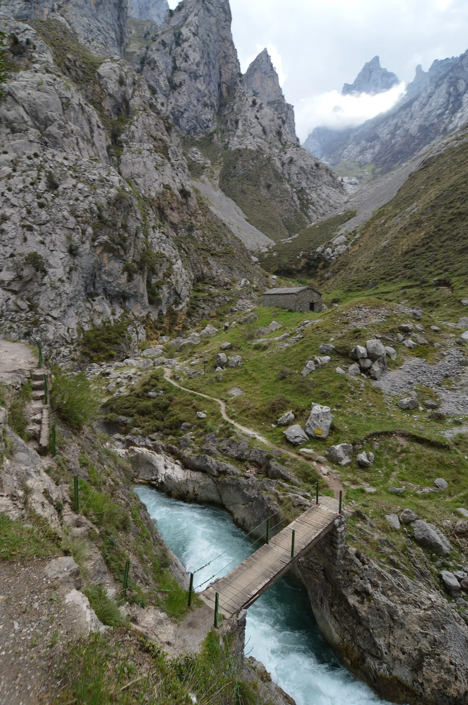
The path began life as a maintenance track for a hydroelectric canal. According to Turismo Asturias, the canal was built between 1916 and 1921 and the path walked today dates from 1945. That explains why it is fairly level for a mountain walk, with tunnels blasted through the rock, “windows” opening onto the gorge and bridges such as Bolín and Los Rebecos.
Fairly level does not mean easy. Turismo Asturias rates the return walk from Poncebos as very difficult (22.1 km, 831 m of cumulative ascent, over 5 hours). The National Park grades it medium but stresses that, while the line is simple, the route is long. It is waymarked as PR-AS 229 in Asturias and PR-PNPE 3 by the park.
Status on 4 November 2026: the National Park reports that the trail has reopened along its full length in both directions, after a metal footbridge was installed where part of the path had collapsed. Closures for works or rockfall do happen, so check the park’s notices before you set off.
The big question: it is a linear walk
Poncebos and Caín sit on opposite sides of the massif. By road, Caín is reached from the León side (via Riaño and the Pontón pass, according to the park), so there is no quick way back to your car if you finish at the far end. Your options:
- Out and back from Poncebos. The usual choice from Asturias and the one Turismo Asturias describes: 22.1 km in total. You depend on nobody, but it is a long day on your feet.
- Walk as far as you like, then turn round. The park itself suggests that less experienced walkers do just part of the route and plan their return accordingly. Even the first few kilometres from Poncebos give you a real sense of the gorge.
- One way plus a 4x4 transfer. Turismo Asturias notes that if you walk in one direction only, you need to hire a specialist 4x4 transport company. Book before you go and confirm the pick-up point and time.
- The long version from Posada de Valdeón. The park describes the Posada de Valdeón–Caín–Poncebos route (21 km, with 899 m of descent and 160 m of ascent). You will need transport sorted at both ends.
Tip: decide how you are getting back before you start walking, not halfway along. And set yourself a turn-round time, even if you have not reached Caín.
Getting to Poncebos from Gijón
By car, head east to Arenas de Cabrales, in eastern Asturias, then take the road up to Poncebos. According to Turismo Asturias, the trail starts next to the Bulnes funicular car park in Poncebos.
During regulation periods the regional government runs a public transport plan to ease congestion. In 2026 it applied from 28 March to 5 April, 1–3 May, every weekend in May and from 1 June to 12 October. Buses leave from Arenas de Cabrales, stop at the Ovar car park (about 146 spaces, no space guaranteed) and reach Poncebos in around 15 minutes. Details are in the Turismo Asturias access plan (in Spanish); the calendar changes every year.
Without a car, you would first need a regional bus to Arenas de Cabrales (see alsa.es) and then the Poncebos bus on the days it runs. It can be done, but it leaves little slack for the walk itself. Outside the season, have a look at the organised trips on our tours and activities page.
What it demands and what to bring
- Proper hiking boots. The park always recommends them: the path has loose stones.
- Water and food for the whole day. There is no drinking water on the route, and the park advises against drinking from springs in low-lying areas or where livestock graze.
- A waterproof and a warm layer, even if it is sunny in Gijón, plus sun protection. For mountain walks the park also suggests a head torch and a whistle.
- Full attention. There are no railings and some stretches are high above the river. Let others pass calmly at narrow points and keep your hands free.
- Children: Turismo Asturias recommends the walk for over-12s; younger children should always hold an adult’s hand on the inside of the path.
- Dogs: on a lead at all times. On the Cares, retractable leads are banned and fixed leads may not exceed 1.20 m. Travelling with a dog? See our guide to Gijón with dogs.
- Bikes: not allowed on the trail.
- Livestock and mastiffs: the big dogs guarding the flocks are working animals. Keep your distance and do not feed them.
- Emergencies: call 112, the Europe-wide emergency number. Mobile coverage is patchy, but 112 often gets through where ordinary calls do not. If you walk alone, tell someone your plan.
When not to go
- In rain or strong wind, and on the days after. Both the park and Turismo Asturias warn that rockfall risk rises in those conditions.
- When the mountain forecast is poor. Check the AEMET mountain forecast for the Picos de Europa, not just the Gijón weather: it can be sunny on the coast and foggy or stormy in the gorge. Our page on the weather in Gijón has more on Asturian weather.
- If you have not sorted your return, especially if you plan to finish in Caín.
- If you want an easy stroll with small children. The Covadonga lakes are a better fit.
- On peak summer days, if crowds bother you. The transport plan exists precisely to reduce crowding in high season. Start early or pick a weekday.
How it fits with other day trips from Gijón
The Cares takes a full day, so do not try to squeeze much else in. If you have several days in eastern Asturias:
- Covadonga and the Lakes, also inside the National Park, are the gentler alternative and the better choice for young children or less regular walkers. See Covadonga and the Lakes from Gijón.
- Llanes and Ribadesella make a good rest day for tired legs: coast, harbour towns and beaches. See Llanes and Ribadesella.
- Bulnes: the funicular leaves from Poncebos, the same starting point as the Cares. Doing both in a single day is a lot; pick one.
To compare with other options, head back to our guide to day trips from Gijón.
Frequently asked questions
How long is the Cares Gorge trail?
It depends how you do it. Turismo Asturias gives 22.1 km for the Poncebos–Caín–Poncebos return walk, with 831 m of cumulative ascent and more than 5 hours of walking. The National Park gives 21 km for the long one-way version from Posada de Valdeón to Poncebos.
How do you get back if you only walk the Cares one way?
Caín and Poncebos are on opposite sides of the mountains and the road between them is a very long detour, so you cannot simply hop back to your car. Turismo Asturias says the alternative to walking back the same way is to book a 4x4 transfer with a specialist company. For most visitors, the easiest plan is an out-and-back from Poncebos, turning round whenever you have had enough.
Is the Cares Gorge trail dangerous?
It is a well-built path, but a mountain one: there are no railings, some sections run high above the river and rockfall is possible along the whole route, especially in and after rain or wind. Plenty of people walk it safely with proper boots, good weather and full attention; it is not the place for small children running ahead or for bad weather.
Can children walk the Cares trail?
Turismo Asturias recommends it for children over 12, with younger ones always holding an adult's hand on the inside of the path. Bear the total distance in mind: a short out-and-back may suit a family better than the full route.
Can I get to Poncebos by bus from Gijón?
During the summer regulation periods the regional government runs buses between Arenas de Cabrales and Poncebos (in 2026, until 12 October). To reach Arenas from Gijón, check regional routes on alsa.es. Outside those dates, a car or an organised excursion is the practical option.
Sources
- Turismo Asturias – The Cares Route — 4 November 2026
- MITECO (National Parks) – Picos de Europa: PR-PNPE 3 Ruta del Cares — 4 November 2026
- Picos de Europa National Park – Cares trail reopened in full — 4 November 2026
- Picos de Europa National Park – Precautions on mountain trails — 4 November 2026
- Picos de Europa National Park – Plan your visit — 4 November 2026
- Turismo Asturias – Public transport access plan for the Cares, Bulnes, Tielve, Sotres and Pandébano (2026) — 4 November 2026
- AEMET – Mountain forecast: Picos de Europa — 4 November 2026